Tuesday, 28 April 2009

Day 14 Pics

Try and contain yourselves...


We just about managed to find another person to take one for us:


Duncansby Head, where John O'Groats should be, a couple of miles further on.


Dunnet Head, at the actual most Northerly point

Day 13 Pics

As you can see, day 13 was very much
characterised by nothing. There was an abundance of this everywhere we went.


Nothing over here:


Not much in this direction either:

Monday, 27 April 2009

Epilogue

Firstly, we should point out that we WILL be adding those photos that you've all been waiting for just as soon as we get the chance. You'll have to hold the anticipation just a little bit longer...


We've had a great ride - well, several - over the past two weeks. On the whole, we've been treated very kindly by the April weather, which may be the only reason we've survived Northern Scotland in not much more than T shirts and shorts. We've had many great encounters with total strangers helping us out, and being stopped in the street and sponsored without even asking. We've had some memorable climbs, some amazing descents and enjoyed spectacular scenery almost all the way. There have been some tough days, a few unintentional detours, and of course two unplanned dismounts. Generally though, we feel like we got away with it considering our almost complete lack of knowledge and experience.

We've found it hugely uplifting to see that so many of you have been following our progress, and really appreciated all (well, most) of your comments as we've gone along.

Thanks very much to the WAGs for their support not only over the last few weeks but also the previous many months, when it seems like we've been going on about bikes to a totally ridiculous extent.

Thanks of course to everyone for the generous sponsorship that you've all come forward with - it's thanks to you all that we've raised what promises to be close to £3000 for Leukaemia Research, and thereby legitimised the whole trip.

Needless to say, all this raises the inevitable question. What's next...?

Day 15 - John O'Groats to civilisation

Just when you thought it was all over....

As Pam said, we still had a reasonable ride to do this morning, which was - of course - complicated by the howling head wind we had to fight all the way to Wick. Upon our arrival there we managed to seek out the only bike shop in town, who we'd phoned ahead to arrange some assistance with packing up our bikes ready for the flights. Although there were no signs of life from the shop whatsoever, we were helped out by a lovely lady from the bakery next door, who was just phoning the owner when we walked past. Not sure whether this was luck or if we had actually made a successful arrangement (there were some language difficulties over the phone. He may have been speaking in German...). Anyway, we again explained that we needed some help with loosening bits and pieces and some packing materials...and were met with blank looks. For some considerable time. As we were under a little time pressure at this point, the next half hour in the bike shop was a little tense, as we went round in circles explaining what we needed and generally being met with no response. Just when we were giving up hope, he emerged with 4 bike boxes, all of which only slightly too small to be perfect. He then proceeded to drive them up to the airport for us, where we set about fashioning some bike box collages in front of check in. By some minor miracle, this turned out successfully (at the time of writing, we're not sure how successfully, as the bikes are somewhere in transit still), and we checked in with moments to spare. We're now sitting in Edinburgh airport with a few hours to kill while we wait for our connection home. Fingers crossed the bikes will be there too.

Sunday, 26 April 2009

Day 14 Stat

Day 14: Start 0800, Finish 1530, 79 miles. LEJoG total distance covered 1022.5 miles!

Day 14 - Tongue to John O'Groats

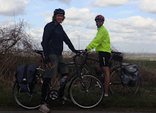
The boys have made it! All is good and they are on their way out to celebrate with a few beers.

They set out from Tongue at 8am. The weather was looking pretty ominous, it was very overcast looking like it could rain; fortunately they didn't get too wet.

They spent the morning cycling along winding costal roads, which were very hilly. Apparently this was good as it kept them warm whilst the weather was very cold. There was a big side/head wind the whole way which made it pretty hard going. They deliberately pushed onto the last town (or only town) on the north coast called Thurso. They have described this town in words that my innocent ears should not have heard, so to make it slightly politer, it was a hole. It was approximately 12noon and the town was shut, being a Sunday. A very drunken man pointed them in the direction of the only open pub. They describe this pub as extremely scary (again using words I should not be subjected to), being full of men in their 20's with black eyes, bruises and all very, very drunk. They had a quick lunch whilst having abuse thrown at them about cycling. They have said they thought they would die or at least get a little battering, fortunately they escaped with their lives, their bikes were still locked up outside and they quickly left this town.

Having left Thurso they decided to take a detour from their planned route and went to Dunnet Head, the most northerly point of mainland Britain. They suggested that the views should have been amazing however it was overcast and misty so they couldn't see much.

They headed on to John O'Groats and in the last 15 miles the sun started to burn through. They reached John O'Groats at about 3.30pm. They have said that they celebrated with a manly handshake and there was no funny business.

Again they describe John O'Groats as not being the most attractive of places with a few tacky souvenir shops, a derelict hotel and a couple of dilapidated buildings. The sign (like at Land's End) was missing, but there was a note saying that if you wished to have your photo taken by the sign, call this number and the photographer would be there quickly as he was only a few miles away. They decided to go for the official picture so rang the guy only to be told that he was away for a few days so tough luck. They did however go for a few pictures next to the white post, just like at Land's End. They have also told me that for all of you that have said you would sponsor more if there was BARE-CHESTED MANKINI photos, they have been taken, and they really deserve a lot more money as it was only 3 degrees and not good for their health. Photos to be posted at a later date.

The most surprising thing about John O'Groats is that it was not the end of the country. They looked at their maps and realised that 2 miles on was a point called Duncansby Head. So to be able to say they truly reached the end, they carried on. Duncansby Head was actually beautiful with a lighthouse and a cliff full of birds. A little way along the cliff you could see some impressive stacks and felt like you really were at the end of Britain. They headed back to John O'Groats, went to the pub and had a pint to celebrate.

They are staying in a youth hostel about 2.5 miles from John O'Groats which they again describe as a dive but have had to head back to John O'Groats as it is the only place with a pub.
Having finished the cycling, tomorrow they have to get up early and, umm, start cycling 20 miles to Wick airport, where there will be some logistical miracle which involves getting their bikes flight ready, and on a plane to Edinburgh. If they make it to Edinburgh they will try to update the blog.

Saturday, 25 April 2009

Day 13 stat

Todays stat (I can't access the stat chart)


Day 13: Start 0945, Finish 1545, 48 miles. 1 wax-work.

Day 13 - Carbisdale Castle to Tongue

Pam here again. The boy's have asked me to update the blog as they have reached parts of Scotland where the internet doesn't exist!

They started out from the spectacular castle this morning. Today’s route led them down a single carriageway road for the whole day. Apparently this part of Scotland was quite desolate and they had to stop and add extra layers because the temperature dropped as they gained height on some of the hills.

They took a break at the rather strange Shin waterfalls which are owned by Mohammad Al-Fayed and as such, have an out of place extravagant visitors centre. The visitor centre includes a small Harrods shop and a life-size wax work model of Mohammad Al-Fayed wearing a kilt!

As for the rest of the day the places they had marked down as possible lunch stops were all deserted with some suggestion that they had gone into administration. Consequently they ended up eating their lunch at the end of someone’s driveway in the tiny village of Altnaharra, sheltering from the elements. The village only had 3 or 4 houses.

They have also asked if anyone can explain why half of the road signs are in German, any ideas?

They have now reached tonight’s destination in Tongue and have in turn reached the north coast and have seen the sea. Tomorrow John O'Groats!

Tomorrow the boy's won't be able to do the blog as there is no internet access in John O'Groats but hopefully they will be able to get hold of me and I'll fill you in. The boy's are hoping that they will be able to do a blog entry from Edinburgh airport on Monday.

Friday, 24 April 2009

Day 12 - Loch Ness to Carbisdale Castle

Day 12 started with the recovery from the evening of day11.

We had been forced out of our accommodation to search for food and warmth (no bad thing since it was a hole, as we may have mentioned), and decided to return to a hotel that we'd passed on the way in. We knew that this was 3 miles along a fairly busy A road, or indeed a pleasant stroll along the Great Glen Way, which runs parallel. Since this was our only option inside 10 miles, and had looked pretty nice, we decided that a stroll was in order. Having stopped for a look in on the way, we knew that we had until 8.30 to get our orders in for the bar food, so leaving at 7 seemed like it would give us ample time. It was all going smoothly (despite our lack of maps, suitable clothing, water supplies, or any real idea of where we were going), until Dan's Dad suggested a left turn (by phone) at a fork in the path. half an hour later, and on top of a huge mountain, things were not going quite so well. WE seemed to have left all civilisation behind and found ourselves with cliffs to our left - where the hotel should be - and dense forest to our right, which not only meant we couldn't see anything, but also contributed to the gathering gloom. This continued until such a time as a decision was made that turning back would leave us insufficient time to eat, and hence a spot of fell running was the only option open to us. Nice way to work up an appetite, anyway. After an hour and ten minutes, and against all the odds, we arrived only slightly hot and sweaty at a pretty smart hotel bar, but once again the charity T shirts made up for a lot in terms of lack of cleanliness. And a bit of a whiff. After a very enjoyable dinner, we decided that all things considered, a taxi home was probably for the best...


After the previous night's shenannigans, we were glad of another fairly light day, which again was following Lochs for the first part before turning to cross a few more Bens and Glens. Skies remained overcast all day but we again managed to cheat the rain (how long can this possibly continue?), and arrived at our truly spectacular castle/hostel in plenty of time to check it out while it was still quiet.
As you can see, it's a pretty spectacular place. The first couple of pics are the outside as you arrive and then from the front. Although the view outwards is very good, it didn't really show up too well in our pictures. As with every good Youth Hostel, we have a lovely sculpture gallery just outside our bedroom, which you can see here.
(All being well) tomorrow we should hit the North coast - almost done...

Thursday, 23 April 2009

Day 11 Pics (part 2)

The view from our YHA bedroom window (the only good thing about this hole):


Dan wondering whether it's just all too much (if you can make him out...):


Invermoriston falls:


A stop for lunch next to Loch Lochy, which turned out to be an amazing picnic spot: